See exactly where every site photo was taken

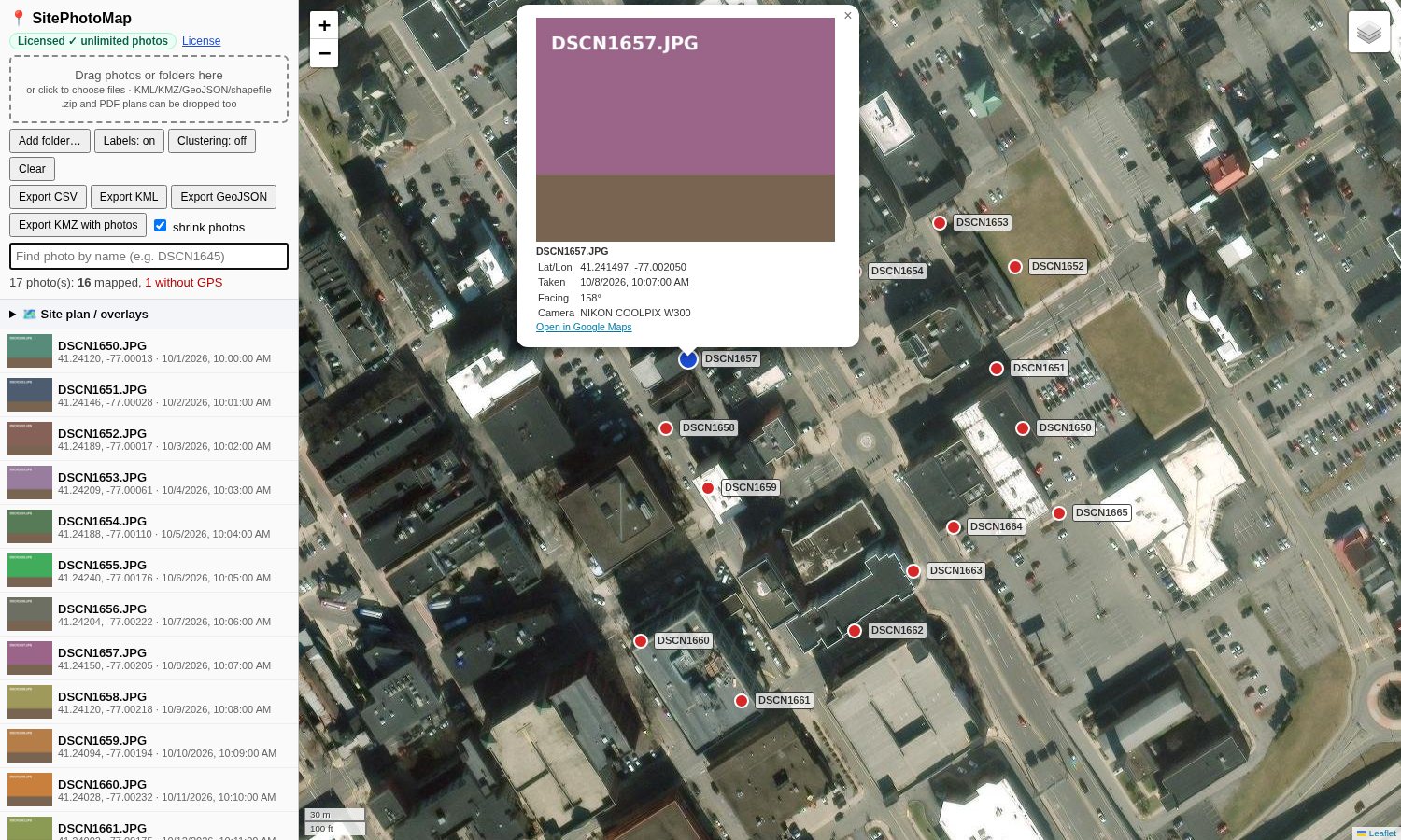
Drag your field photos into SitePhotoMap and each one appears as a labeled dot on a satellite map, read straight from the photo's GPS location. Click a dot to see the picture. No more guessing which corner of the site DSCN1645 came from.

Runs in your web browser Β· Nothing to install Β· Your photos never leave your computer
SitePhotoMap showing geotagged site photos as labeled red dots on a satellite map, with a photo popup open

How it works

Map geotagged photos in under a minute, straight from the folder your field staff sent you.

Drag in your photos

Drop a handful of photos or a whole folder onto the page. JPEGs from phones, drones, and GPS cameras all work.

See them on the map

SitePhotoMap reads the GPS location stored in each photo and places a labeled dot on satellite imagery, so you can see where each photo was taken at a glance.

Click, share, export

Click any dot to open the photo with its date, direction, and coordinates. Export to Google Earth, CSV, KML, or GeoJSON for reports and GIS.

Built for AEC field and office staff

Everything you need to turn a pile of site photos into a photo GPS location map your whole team can use.

πŸ“

GPS dots and labels

Every geotagged photo becomes a dot labeled with its file name. Search by name to jump straight to a photo, and switch on clustering for large sets.

πŸ›°οΈ

Satellite map

High-resolution aerial imagery with road and place labels, plus street and topo basemaps.

🌍

KMZ for Google Earth

Export one KMZ file with the photos embedded. Open it in Google Earth and click a pin to see the picture, even offline.

πŸ“„

CSV, KML and GeoJSON exports

Send photo locations to Excel, Civil 3D, ArcGIS, QGIS, or any GIS tool. Includes date, altitude, camera direction, and camera model.

πŸ—ΊοΈ

Site plan overlays

Load KML, KMZ, GeoJSON, or zipped shapefile layers, or pin a PDF or image site plan to the map with a few control points.

🧭

Photo details

See when each photo was taken, which way the camera was facing, and open its location in Google Maps with one click.

Your photos never leave your computer

Site photos can be confidential. SitePhotoMap does all of its work inside your browser, so there are no uploads and no cloud storage.

  • Photos are read and mapped on your own machine.
  • No account or sign-up needed to start.
  • The only thing sent over the internet is a license key check when you activate a paid license, plus the map imagery itself.
  • Friendly to firm IT policies: there's no software to install and no files to upload.
πŸ”’

Local processing. When you drop photos into SitePhotoMap, they stay on your computer. Exports are created right there and saved to your Downloads folder.

Nothing to install. It runs in Chrome, Edge, Firefox, or Safari.

Simple pricing

Try it free with up to 12 photos at a time. Unlock unlimited photos when you need it.

Free

$0
No sign-up
  • Up to 12 photos on the map at once
  • Satellite, street and topo maps
  • All exports and site plan overlays
Try it free (12 photos)

Unlimited

$9.99 per user
One-time payment Β· license for one computer
  • Unlimited photos at once
  • Everything in Free
  • License key delivered instantly by email
Get unlimited

Frequently asked questions

Questions we hear from field staff, project managers, and IT.

Does SitePhotoMap upload my photos?

No. Your photos are read and mapped entirely inside your web browser on your own computer. They are never uploaded to us or to any cloud service. The only data sent over the internet is the map imagery and, if you buy a license, a quick license key check.

What cameras and phones work?

Any camera that saves GPS coordinates in the photo works, including iPhones and Android phones with location turned on for the camera, drones (DJI and others), and GPS-enabled cameras like the Nikon COOLPIX and Ricoh rugged models. JPEG works best. HEIC, TIFF, PNG, and DNG files are read when the browser supports them.

Do I need to install anything?

No. SitePhotoMap runs in a modern web browser such as Chrome, Edge, Firefox, or Safari. Open the page, drag in your photos, and you're done.

Can my firm buy multiple licenses?

Yes. Pricing is $9.99 per user, and you can buy as many licenses as you need. Buy several at once at checkout, and each user gets their own key. For a larger team, email us and we can help.

How many computers does one license cover?

One license covers one computer. If you use SitePhotoMap on another computer, that computer needs its own license. If you replace your computer or clear your browser data, email us and we'll reset your license so you can activate it again.

What if some photos have no GPS location?

They still appear in the photo list, grayed out and marked "No GPS data", so you know which ones couldn't be placed. They don't count toward the free 12-photo limit. On phones, make sure location access is turned on for the camera app. Some photos lose their GPS data when they're sent through messaging apps or social media, so ask field staff to send the original files by email, a shared drive, or a cable.

Can I open the results in Google Earth or my GIS?

Yes. Export a KMZ with the photos embedded for Google Earth, or export CSV, KML, or GeoJSON for Excel, ArcGIS, QGIS, Civil 3D, and other tools.
Find out where that photo was taken in seconds

The fastest way to see where a photo was taken: drop in your next batch of field photos and see them on the map. It's free for up to 12 photos.

Try it free (12 photos)